|
By Pam Tice, Bloomingdale Neighborhood History Group Planning Committee In the 1890s, a bicycling craze swept America as men and women purchased bicycles and took to the roads. The safety bicycle, a machine much like the one we have today with equal-size wheels and inflated tires, fueled the craze as the model became widely available by the mid-1880s. Bicycles cost from $45 to $75, making the craze very much a middle-class phenomenon. In our Bloomingdale neighborhood, with its paved roadways and two parks, the bicycle craze became part of street life. Central Park West and Eighth Avenue was paved up to 135th Street by 1898, although riders found the darkened street under the El (above 110th Street) hard to maneuver. Central Park became popular for bicycling by the mid-1880s after Park rules allowed cyclists to ride on the drives, already busy with carriages and horses. The Boulevard, later named Broadway, was a popular bicycling route, from Columbus Circle up to Grant’s Tomb and the Claremont Inn. Certain parts of the new Riverside Drive also attracted wheelmen and wheelwomen, as the bicyclists were called. In the spring of 1896, traffic counters noted more than 14,000 bicyclists over a sixteen-hour period. 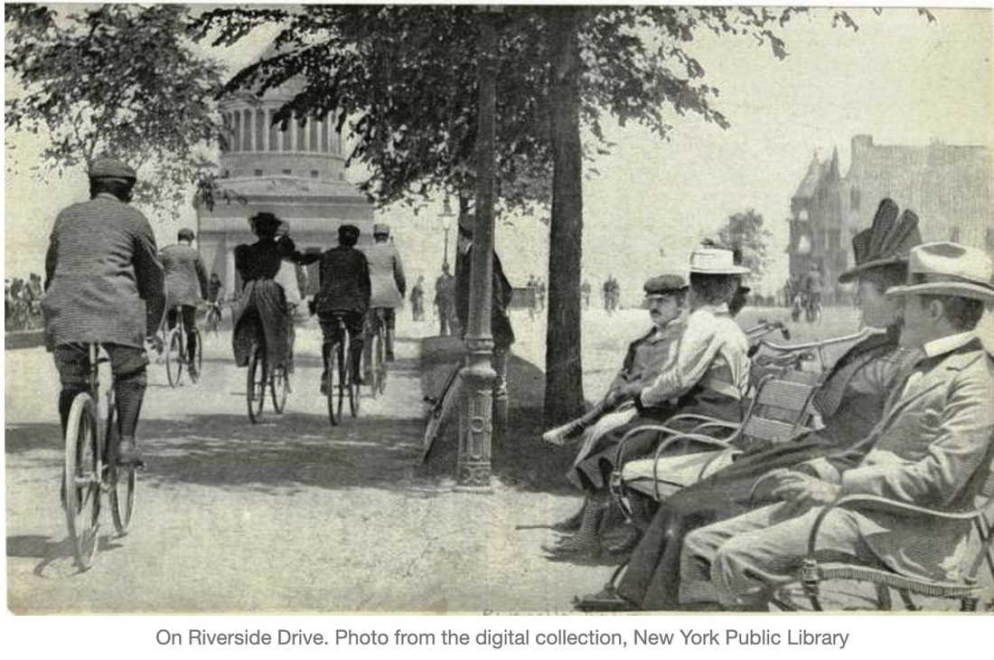
0 Comments
The Bicycle Craze Comes to Bloomingdale
The Solar Eclipse of 1925 Comes to Bloomingdale Bloomingdale Before the Road Neighborhood Charities: House of Mercy Bloomingdale in 1855 One Hundred Years Ago: Bloomingdale Traffic Orphan Houses of the Upper West Side Bloomingdale Neighbor Augusta Stetson and the Church at 96th Street and Central Park West Post #1: Bloomingdale: Colonial Times and after the Revolutionary War Post #2: 18th Century Bloomingdale residents before the American Revolution Post #3: The Revolutionary War in Bloomingdale Post #4 Enslaved African Americans in Bloomingdale Post#5 Bloomingdale Grows and Prospers 1790-1820 Post #6 Along the Bloomingdale Road After the Revolution: Taverns and Tavern Keepers Post #7 Bloomingdale Goes to School 1790s and early 1800s Prohibition in Bloomingdale Spanish Flu in Bloomingdale: A Search for How Our Neighborhood Coped in 1918 Growing Old in Bloomingdale: Nineteenth Century Homes for the Aged, Part 1 Growing Old in Bloomingdale, Part II Growing Old in Bloomingdale Part III Our Bloomingdale Wall Provisioning Bloomingdale: Stores that fed the residents of Bloomingdale: Part 1 Bloomingdale Neighborhood Stores, Part Two New York’s Colored Orphan Asylum Bloomingdale’s Finest Mansion: From Elmwood to Elm Park, 1764-1891 Bloomingdale’s West 96th Street Was the Focus of the 1925 Solar Eclipse Dining Out in Bloomingdale ¡Unidad Latina! — Political Activism on the UWS in the 1960s and 70s Little Coney Island on West 110th Street Making Music in Bloomingdale The Home for the Relief of the Destitute Blind The Bloomingdale Insane Asylum The New York Pasteur Institute on Central Park West at 97th Street John Clendening, Esquire, and his Bloomingdale Estate The Lion Brewery, the Lion Park, and the Lion Palace Battle of Harlem HeightsBloomingdale History Map History Detectives: Researching Your Building Bloomingdale History Map Bloomingdale/Manhattan Valley Chronology THE RISE AND TRAGIC FALL OF A MODEL WHO BROKE THE RULES The Old Community on West 98th and 99th Streets The Story of 891 Amsterdam Avenue and how it became a New York City Landmark The Ninth Avenue El Measure of Manhattan Neighborhood Nomenclature by Pam Tice, Bloomingdale History Group Planning Committee “The Sun may be in eclipse, but New York, never!” -Mayor John F. Hylan, quoted during the January 24, 1925, total solar eclipse over New York City As we look forward to the solar eclipse on the afternoon of April 8, 2024, it’s a good time to remember the eclipse on the cold morning of January 1925 when the Bloomingdale neighborhood was at the center of attention. This year New Yorkers will see the sun 90% obscured by the moon. In 1970, many Upper West Siders gathered in Riverside Park to experience the 96% eclipse. But in 1925, it was a total eclipse. The last total eclipse had been 450 years before, and the next two were predicted for 2079 and 2144. The path of totality was a bit undefined in the days leading up to the 1925 event. Initially, the line of totality was predicted to be between West 72nd Street and West 110th Street. A few days later, the line was set north of West 83rd Street. Following the event, the line was firmly established: between West 96th and 97th Streets, or between 230 and 240 Riverside Drive. Pundits dubbed it “The West 96th Eclipse.” The Daily News published this map before the event. 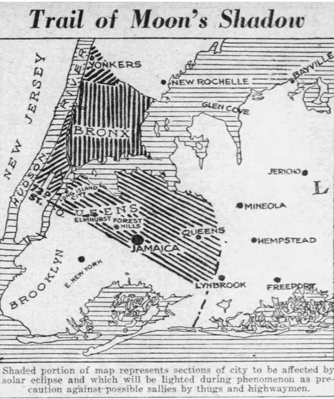 written by Pam Tice, member of the BNHG planning committee The story of the House of Mercy, located at the far end of West 86th Street on the Hudson River, is a tale of women’s work. The House was founded in 1855 by a devoted Episcopal woman, Mrs. William Richmond, who used her religious convictions and social skills to establish the charitable home. In 1863, the House of Mercy was put under the management of Episcopal nuns whose establishment was a historical moment for the church. It is also the story of young women of New York City in the mid-nineteenth century and their struggles that reflect the social mores of the patriarchal culture of that era. 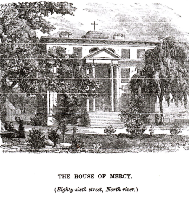
written by Gil Tauber, member of the BNHG Planning Committee
The Bloomingdale district of colonial New York was a rough triangle of land, about 3.5 square miles in area, stretching along the Hudson River from about 42nd Street to 129th Street. Its southern boundary was a broad creek, bordered by marshes, known as the Great Kill. It was bounded on the east by the Town of Harlem, a peculiar municipal entity that had been established by Peter Stuyvesant and continued by his English successors despite being entirely within the City of New York. Accounts of the history of Bloomingdale rightly note the importance of the Bloomingdale Road. First laid out about 1708 as part of the provincial highway system in the Province of New York, the road is credited with changing Bloomingdale from a rural backwater to a district of fashionable country estates. In the 19th Century, its prestige was such that property near the road, even far to the south, was described as being in Bloomingdale.[1] However, there was a Bloomingdale well before the road, and the creation of the road was itself a step in a more gradual process. This paper examines the history of Bloomingdale up to the period when the road was laid out. by Pam Tice, member of the Bloomingdale Neighborhood History Group Program Committee
A recent question from a family researcher led me to the 1855 New York State census. As I located our Bloomingdale neighborhood in the city’s 12th Ward, I discovered how the pages of the census could become a lens into life in Bloomingdale in the mid-19th century. This was Bloomingdale before the Civil War, the Lion Brewery (1858), the 9th Avenue El (1879), and before most of the streets were laid out. New York City historians covering this period characterize the Bloomingdale neighborhood before the Civil War as a place of “country seats,” many developed in the late 18th and into the early 19th centuries by wealthy merchants. They built in the bucolic Bloomingdale to escape the crowded downtown, especially when a cholera or smallpox epidemic threatened. There’s scant attention paid to the working-class and poor residents of the neighborhood except to note that there was a “village” around 100th Street. Even as late as 1868, in an Atlantic Monthly article, Bloomingdale was described as a rural village near the city with family mansions and large asylums for “lunatics and orphans.” (The Bloomingdale Insane Asylum opened in 1821 and the Leake and Watts Orphan House opened in 1843.) The author describes the Bloomingdale Road as “Broadway run out into the country,” a road serving “fast-trotting horsemen.” The Hudson River Railroad runs beside the river with “much of the intervening ground occupied by market gardens.” In his book on the history of St. Michael’s Episcopal Church, located at today’s Amsterdam Avenue and 100th Street, John P. Peters describes two projects that changed the character of Bloomingdale. The first was the Croton Aqueduct, a “monumental structure” that emerged from underground at 113th Street and Tenth Avenue, turning eastward through Manhattan Valley, and running down the westside to West 84th Street. by Pam Tice, member of the Bloomingdale Neighborhood History Group Program Committee Scrolling through the 1923 Daily News articles about our Bloomingdale neighborhood, I was struck by the number of automobile accidents and deaths, as well as the arrests of drivers who lived here. The Upper West Side, of course, is famous for being the site of the first motor vehicle fatality in the United States, when Henry Bliss was killed as he got off a trolley car on Central Park West in 1899. In June, 1923, Mrs. Howland of West 95th Street was killed by an automobile while on her way home from St. Agnes Chapel on West 91st. Also in June, 13-year-old Theresa Bogert of 933 Columbus Ave. was killed at Riverside Drive and 108th Street while crossing with two young friends and a teacher. In the winter, a snowplow had killed a man on West 106th Street. Little Jimmie Walsh of Amsterdam Avenue was killed in April. Also in April, readers of the Daily News were reminded of the law that automobiles had to stay eight feet away from the area where trolley car passengers were discharged, with a reminder that two people had been killed recently at Columbus and 98th Street getting off the cars, a particularly dangerous location. The Parks Commissioner threatened to close Central Park to automobiles after dark due to the damage done to the Park’s plantings and structures. In June, an auto travelling at 50 miles per hour crashed into a lamppost at West 102 Street, killing the driver Bloomingdale neighbors also got their name in the news as they were charged in Manhattan Traffic Court: Michael McIntyre of 792 Columbus was sentenced to 15 days and had his license revoked for driving while intoxicated; Mr. Scaramellino of 813 Amsterdam spent two days in jail for turning corners too sharply; John McCourt of 832 Amsterdam spent 5 days in jail for speeding, and a cab driver living at 784 Amsterdam was assigned to the Work House for 60 days for driving while intoxicated. There were other incidents involving automobiles, whose drivers the News referred to as “autoists.” The word “car” was reserved for trolleys. Two autos with alleged bandits inside crashed at Riverside Drive and 97th Street. A young woman, screaming and clinging to the running board of a speeding auto that sped down Amsterdam from 86th to 66th Streets with 50 autos giving chase, ended up in an overturned auto and a bad injury. Just south of Bloomingdale, a speeding auto hit a crosstown bus, exploded its gas tank, and kept going as a ball of fire for several blocks since it was speeding at 40 miles per hour. 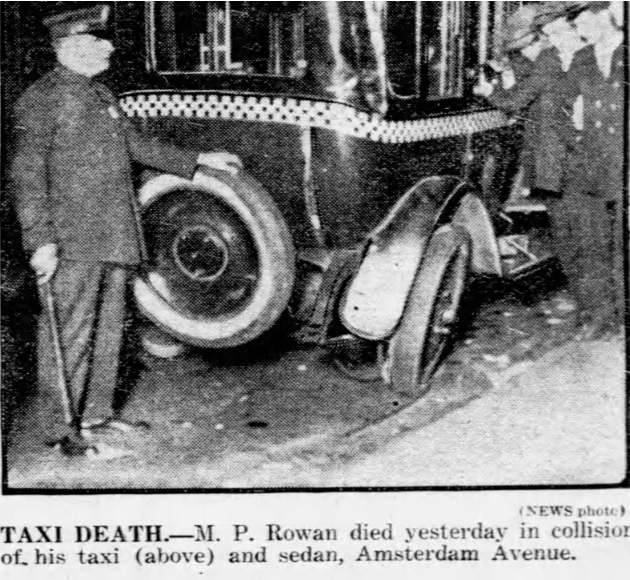 by Pam Tice, member of the Bloomingdale Neighborhood History Group Planning Committee The Upper West Side, a suburb in the early to mid-19th century, provided an excellent location for an orphanage. Land was cheap, the neighborhood’s country-like setting provided the fresh air children needed, and there was even space to grow food. New York’s increasing immigration in the 19th century expanded both poverty and disease in the city, leaving many parents unable to cope with caring for their children. The children of the poor who were left to fend for themselves were viewed by the City’s reformers as a threat to civic stability. In his 1872 book about the city’s many benevolent institutions, the Reverend J. F. Richmond wrote: “Every great city contains a large floating population, whose indolence, prodigality, and intemperance are proverbial, culminating in great domestic and social evil. From these discordant circles spring an army of neglected or ill-trained children, devoted to vagrancy and crime, who early find their way into the almshouse or prison, and continue a life-long burden upon the community.” A Police Chief called them “vagrant, vicious and idle children.” The descriptive language used reflected the general outlook of New Yorkers toward the thousands of immigrants who came to the New York City in the 19th century and the moralistic tone of the Victorian age. Religious institutions became the caretakers for many of these orphaned children. Starting in 1850, Catholic children were cared for in orphanages on Fifth Avenue and Madison Avenue in mid-town, and later moved to the Bronx. In 1860 the Hebrew Orphan Asylum was founded at Amsterdam Avenue at 137th Street. In 1837, the Colored Children’s Orphanage was built at Fifth Avenue and 42nd Street. This one became famous when it was burned during the draft riots of 1863. It moved to Amsterdam Avenue and 143 Street, and later to Riverdale. South of our Bloomingdale neighborhood was the New York Orphan Asylum Society, organized by Isabella Graham in 1806. Initially, the group had an asylum in Greenwich Village. Elizabeth Schuyler Hamilton, recently widowed, was an early supporter. By 1839, the Society relocated to a large facility at Riverside Drive at 73rd Street where they stayed until the end of the 19th Century. The organization re-located to Hastings-on-Hudson where they are still in operation today as Graham Windham. Their property on Riverside Drive was purchased by Charles Schwab, who built his French Chateau on the site 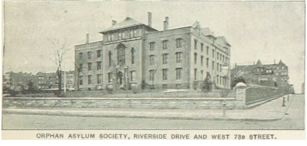 by Pam Tice, member of the Bloomingdale Neighborhood History Group Program Committee The First Church of Christ Scientist, at 96th Street and Central Park West, will soon become the home of the Children’s Museum of Manhattan. Recent announcements of the conversion led me to look at the history of this imposing granite structure. It is a tale of two (or maybe three) women seeking power in the public sphere as they struggled to dominate in a new American religion, Christian Science. The church was the project of Augusta Stetson, who came to New York City in 1886 to establish the Christian Science church here, working at the behest of Mary Baker Eddy, the Bostonian founder. Augusta Emma Simmons Stetson was born in 1842 in Maine and raised in a strict Methodist home. When she was 22 years old, she married Captain Frederick J. Stetson, a veteran of the Civil War, and a shipbuilder with an association with a company in London. The couple left the United States to live in London, and then in Bombay, India, and in Akyab, in British Burma, for a number of years. The Stetsons returned to Boston in the 1880s when Mr. Stetson’s health declined. Augusta enrolled in the Blish School of Oratory with the idea she could earn money to support the couple by giving public lectures. She sought to become an elocutionist at a time when the public lecture circuit was popular. For her to consider entering the public sphere during Victorian times--when women were expected to stay confined to home duties--speaks to Stetson’s drive to become a public figure and a leader. She is described in many biographies as tall, elegant in appearance, with a charismatic personality and a resonant voice. 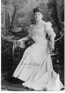 by Pam Tice, member of the Bloomingdale Neighborhood History Group Introduction A few months ago, a new website developed by John Jay College caught my attention. Like many institutions of higher education, the College was exploring the link between slavery and the famous man whose name adorns it. One of the resources used was the 1790 federal Census. I looked up Charles Ward Apthorp, whom I had written about previously, one of the colonial property owners in our Bloomingdale neighborhood. He owned eight slaves. That got me thinking: who were the other people in this census? How was the Bloomingdale neighborhood settled in the era before the Revolution? What was Bloomingdale like after the Revolution and in the early 1900s? I started to dig a bit deeper into the Bloomingdale history, beyond the work of numerous local historians who write about a particular property owner and the history of a mansion house, as I myself had done in writing about Apthorp’s mansion that became Elm Park. The Bloomingdale Road, authorized in 1703, and laid out in 1707, was key to the area’s development; Bloomingdale became more like a suburb of the city than what we call a neighborhood today. I am especially grateful to my colleague at the Bloomingdale Neighborhood History Group, Gil Tauber, for his help on the details of the Bloomingdale Road history. To provide context, I read books and articles about New York City’s colonial history, about how the American Revolution played out here, and the role slavery played in New York City. I also learned about the yellow fever epidemics in the late 18th and early 19th centuries as they played a role in developing our neighborhood, an escape from the crowded streets of downtown Manhattan. The districts of the 1790-1820 federal censuses covered much more geographical space than just our neighborhood. In order to find just the Bloomingdale residents, I first had to learn about many uptown Manhattan families and where they settled. I used numerous publications such as Riker’s History of Harlem, Stokes’ six-volume Iconography of Manhattan Island, and Mott’s New York of Yesteryear, along with innumerable newspaper clippings. (Those books are listed in the Sources section below.) The blog posts that follow share what I’ve learned about colonial Bloomingdale and its history in the late 18th Century and early 19th Century. Along the Bloomingdale Road in the 18th Century Bloomingdale referred to a district on both the lower and upper West Side of Manhattan Island named by the Dutch as Bloemendahl, a vale of flowers. When the British took over the colony in 1664, changing the name from New Amsterdam to New York, they Anglicized the district’s name. Bloomingdale was never an organized village, like New Harlem. Later, Greenwich Village, although not incorporated, also had more specific boundaries than Bloomingdale which remained somewhat amorphous. Later, it would be defined as a settlement around 100th Street and the Bloomingdale Road. Other neighborhood names developed: Harsenville, in the 70s, was to the south, and Vandewater Heights to the north, where we find Morningside Heights today. In his Iconography of Manhattan Island, Stokes cites 1688 as the earliest example he could find of the use of the name Bloemendahl, mentioned in a marriage record of the Dutch Reformed Church. Similar names would be given to other early farms: the de Montayne family named their farm near today’s Morningside Park Vredendal or “peaceful dale.” On June 19, 1703, New York’s Colonial legislature passed an Act naming the Bloomingdale Road as a public road. Later legal actions would cite the fact that it was four rods in breadth as proof that it followed an existing road, since new roads in the Colony were to be six rods. (A rod is 16.5 feet in British measurement.) The existing road was no doubt a Lenape trail, as this was the formation pattern of many Manhattan roads. The Bloomingdale Road would stretch from 14th Street and the Bowery, cross the island in a northwest direction, and end up at the dwelling house of Adrian Hoogelandt at 116th Street, near today’s Riverside Drive. In 1787 legislation about the Road this same place was referred to as Nicholas de Peyster’s barn, the site of Hooglandt’s old house. In 1707, the Committee responsible for surveying the road declared their work finished. Two of these landowners were “Theunis Eidens” and “Captain Key,” who are mentioned in the next post covering property owners. In 1751 legislation concerning the Road, it was allowed to have a breadth of two rods. The City also required the appointment of a surveyor of the public road, one who was a resident of the Bloomingdale district. He was in charge of road repairs and had the authority to summon any number of Bloomingdale inhabitants to work for up to six days each year on the Road. If someone produced a cart, spades and pickaxes, that would be counted as three days of labor. Anyone failing to appear would be fined six shillings. After the Revolution, in 1794, the City’s Common Council decided to “…look into the expediency of continuing the Road until it intersects with the Post Road in Harlem Heights, and to determine if the proprietors through which the Road will pass may be asked of their willingness to give the land for this purpose.” All but two (Molonear and Meyer) were willing, and by 1797 the Council ordered that the new Road should be “put in good order.” Many years later, in 1868, the Bloomingdale Road was officially abandoned after major portions of it had become part of Broadway.  |
||||