|
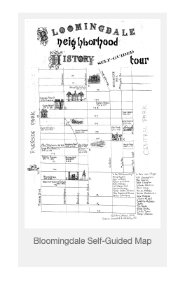
A map of the musical history of Bloomingdale was recently created by Vita Wallace of the Bloomingdale Neighborhood History Group’s Planning Committee. The map is posted here, along with commentary from Vita and photos of a recent BNHG Program that presented the rich heritage of our musical neighborhood. THE MAP (scroll down for Spanish version) 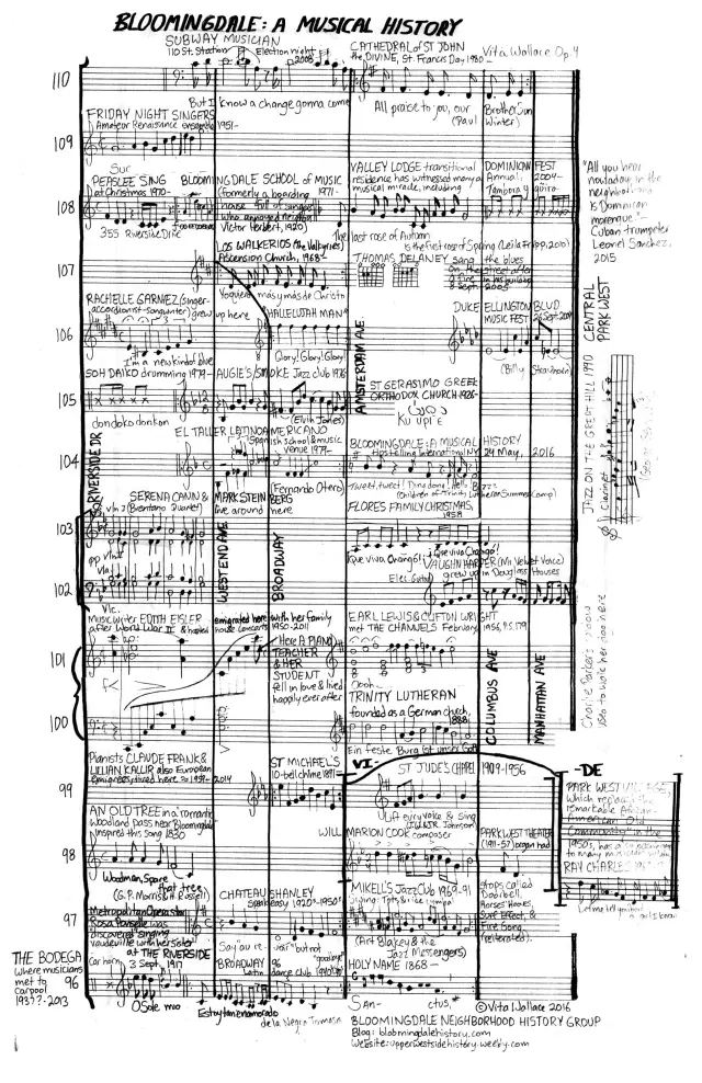
0 Comments
This is another post in a series by Pam Tice, member of the Planning Committee of the Bloomingdale Neighborhood History Group, covering buildings that no longer exist in our neighborhood. 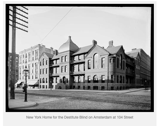 From the mid-1880s, this beautiful red brick building stood at the corner of Amsterdam Avenue and 104th Street for more than thirty years, housing blind men and women in The Home for the Relief of Destitute Blind.
This photograph was taken in 1898 by Robert Louis Bracklow (1849-1919), a New York stationer who was also a talented amateur photographer. The photo gives us a sense of what Amsterdam Avenue looked like with its trolley tracks, fancy street lights, and telephone lines above the street. Mr. Bracklow’s extensive collection is posted HERE by the New-York Historical Society. (Warning: there are more than 2000 photos to look at!) The Society of the same name that built the building had been founded in 1868 by an Episcopal minister, the Reverend Eastburn Benjamin. An 1856 graduate of the Theological Seminary of Virginia, he served as Assistant Minister of St. Ann’s Church for Deaf Mutes in New York from 1864 to 1868. The Rector of that church was Reverend Thomas Gallaudet, whose son later founded Gallaudet University in Washington, D.C. This experience may have given the Reverend Benjamin his interest in establishing an institution to serve the disabled. This post is written by local historian Jim Mackin based on his presentation for the Bloomingdale Neighborhood History group on November 16, 2015. The topic covers two of our themes: the medical history of the Bloomingdale neighborhood, and another building that (almost) is no longer in existence.
Jim Mackin is a member of the BNHG’s Planning Committee, presenting popular presentations on behalf of the group, as well as leading monthly neighborhood history walking tours. It all began in 1769. Two students were graduating with medical degrees from King’s College. Twenty-eight-year old Dr. Samuel Bard gave the commencement speech that so moved city leaders that enough funds were pledged to establish a hospital. In 1776, New York Hospital became the 3rd oldest hospital when it opened just in time to treat some rag-tag colonials wounded by shot from British men-of-war ships moving up the Hudson. Mentally ill patients were treated from the very beginning of the hospital along with all other patients. But the number of mentally ill patients was rising greatly. In 1802 a committee was formed to consider an addition to the building, and any other planning, to accommodate the increase of what were the called “lunatics.” But more radical action was taken by the establishment of a separate and new department in the hospital to accommodate mentally ill patients, and the construction of a separate and new asylum building in 1808. This asylum of 80 beds was the only one of its kind in New York State. New approaches to treatment of the mentally ill by Dr. Pinel in Paris and William Tuke who established the Retreat for the Insane in York, England. Patients were to be no longer kept in seclusion, let alone in chains. Treatment was becoming understood as “moral” instead of “medical”. The changes had sweeping implications: patients were “visited” and physical activity for patients was encouraged. This is the third in a series of posts about buildings no longer standing in the Bloomingdale neighborhood; it was also the subject of an October 5, 2015, BNHG presentation by medical historian Bert Hansen, Professor at Baruch College, part of the BNHG’s series on medical institutions in our neighborhood. Dr. Hansen’s book is listed in the “Sources” section below. The book received awards by the American Library Association and by the Popular Culture Association/American Culture Association.
Our thanks to Dr. Hansen for reading our draft and suggesting changes. Written by Pam Tice, member of the BNHG Planning Committee The New York Pasteur Institute on Central Park West at 97th Street Until the late 19th century, a dog bite was one of the most fearful things that could happen to you. If the dog were rabid, and you showed symptoms, you were sure to die a painful death. An infectious disease in mammals, rabies (lyssavirus) is transmitted through the saliva just a few days before death when the animal “sheds” the virus. Because it affects the central nervous system, most rabid animals behave abnormally. The disease still exists in the United States today, especially in the northeast in raccoons, but most dogs today are vaccinated. Humans, if thought exposed, can get a treatment far easier than the one first devised. People bitten by a rabid dog develop a disease that came to be called hydrophobia, a name used interchangeably with rabies. First displayed in humans as agitation, fever, and restlessness, it soon causes delirium, and then the inability to swallow liquids (hence the name), as even the smallest amount causes painful spasms and gagging. Most people died within a few weeks of contracting the disease. Before vaccinations, an outbreak of rabies among dogs or cats would often bring about a panic calling for all the animals to be destroyed. Until registration of animals became the norm, wild or unmarked dogs would be hunted and killed. That job often fell to a local police officer. This is the second post of a series on Bloomingdale neighborhood places that no longer exist. It was written by Pam Tice, member of the Bloomingdale Neighborhood History Group Planning Committee. When John Randel made his 1818-1820 Farm Maps, he mapped a house on a Bloomingdale hill right in the middle at what would become 104th Street and Columbus/Ninth Avenue. 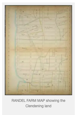 This was the home of John Clendening, a wealthy New York merchant. After assembling the land in several transactions, he called his Bloomingdale farm “Sharon Farm.” Stokes’ Iconography of Manhattan Island includes notes on Clendening’s farm and how it came to be.
John Clendening typified the wealthy merchants who purchased land in the Bloomingdale area on the west side of Manhattan, land that the Dutch had farmed as they settled Manhattan’s northern reaches. The original patent for the area in 1667 was granted to Isaac Bedloe, a New York Alderman. After he died in 1673, Bedloe’s land became divided through property transfers over the years, creating the Charles Ward Apthorp Farm, the Striker’s Bay Farm, the Herman LeRoy Farm, the John Clendening Farm, and a part of the Lawrence Kortwright Farm that became part of Central Park. According to Stokes, the block numbers assigned to the Clendening Farm are 1857, 1838, 1834, 1854, and 1857. Thus, if you are looking at Manhattan property on a map with block numbers, you can identify the area of Mr. Clendening’s estate. This is the first in a series of posts about structures and other features of the Bloomingdale neighborhood that are no longer here. This post was written by Pam Tice, a member of the Bloomingdale Neighborhood History Group’s Planning Committee. For nearly 100 years, the sprawling Lion Brewery — and its nearby Park — took up the blocks 107 to 109 Streets between Ninth and Tenth Avenues, named Columbus Avenue and Amsterdam Avenue in 1890. Built just after the Civil War, by 1879 the space included the Lion Park — a Beer Garden — on part of the 107-108 block east of Ninth Avenue. The brewery operations sprawled between Ninth and Tenth Avenues, including the brewery, the malt house where the barley was converted to malt, ice houses, stables, workshops and private residences. 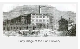 This article was recently posted on the West Side Rag site, written by Marjorie Cohen who is a member of the Planning Committee of the Bloomingdale Neighborhood History Group. Marjorie also arranged a wonderful program for the BNHG on March 16, 2015, when we learned how to research the history of a building. Are you curious about the history of your building, your church, your synagogue, your kids’ school? Or maybe that interesting-looking building down the block? When was it built, who lived there, who was the architect? And what did your block look like in the 20’s, the 30’s, even earlier? The Upper West Side is full of buildings with interesting stories to tell and now, with the emergence of so many high tech tools for historians, researching a building’s history is easier than ever before. At a recent program put together by the Bloomingdale Neighborhood History Group the audience got a terrific short course in how to conduct building research. The program was arranged especially for the BNHG by the staff of the Neighborhood Preservation Center. a partnership of three organizations: the Historic Districts Council, a citywide advocate for New York’s historic neighborhoods; the Greenwich Village Society for Historic Preservation, a leader in the preservation and protection of the architectural heritage and cultural history of the Village; and the St. Mark’s Historic Landmark Fund, a group dedicated to the preservation of the St. Mark’s Church campus where the Center is located. The evening’s featured speakers were Anthony W. Robins, well known NYC architectural historian who has written, taught, lectured and led walking tours on that subject for decades; and Susan De Vries, a New York city history consultant. Robins, the researcher for the current exhibit on NY Transportation Landmarks at the NY Transit Museum Annex at Grand Central Station, gave a thorough power point talk that highlighted links to dozens of specific research tools both on and off the internet and DeVries presented an interesting survey of the typology of west side buildings. Following the two talks, audience members were given the rare opportunity to consult one-on-one with volunteers Sana Afsar, Elizabeth Meshel, Katharine Fields and Hannah Gall who helped them get started on their own research. Audience members received a takeaway compiled by the NPC, with links to online research sources for maps, building documentation, landmark designation reports; a bibliography; a description of the BNHG collection housed at the Bloomingdale Branch of the NYPL; and more. To download a copy of this informative document click to the West Side Rag site, then on the link to the document, positioned at this point in the essay. This link may not be posted for long. And, now that you have all of this invaluable information at your fingertips, there are no more excuses for putting off the start of your building history search project. Happy hunting! BATTLE OF HARLEM HEIGHTS
by Jim Mackin, local historian and member of the Bloomingdale Neighborhood History Group Planning Committee The Battle of Harlem Heights begins with the Knowlton Rangers. They were men, mostly from Connecticut and some from Massachusetts, were who were hand-picked for an elite detachment to be called “Rangers.” There were Rangers in the earlier French and Indian War, but these Knowlton Rangers were the first under Washington. They were the Green Berets, the special forces of their day and they were our first organized espionage unit. Before dawn on September 16th, 1776, the leader of the Knowlton Rangers, Lieutenant Colonel Thomas Knowlton, and from 120 to 150 men, left the front lines along the ridge above “the Heights of Harlem” to see what the British were up to and might do next. They stayed close to the Hudson (then called the North River), passed by the Hoaglandt house at the northern end of the Bloomingdale Road (today Riverside Drive and 114th St) and through the Harlem Heights (known later as Morningside Heights) as futher south to about 106th St and WEA. When the 120 to 150 Knowlton Rangers advanced south to find the British they included Thomas Knowlton’s older brother, Daniel and his 16 year-old son Frederick. At about 106th St and WEA there was a solidly built stone house of farmer Nicholas Jones. The Rangers were moving stealthily through the farm fields when they were spotted by British pickets guarding the Bloomingdale Road. The pickets fired their guns to alert the 2nd and 3rd regiments of Leslie’s light infantry that was camped near 104th St along the Bloomingdale Road. Some of the British fired from 104th St towards the Rangers, and the Rangers fired back from behind one of Jones’s stone walls. Soon, however, 400 British troops materialized and started moving in column up the Bloomingdale Road. Knowlton directed his men to hold their fire until the marching British reached 107th St. Then the Rangers stood up and fired. The British and the colonial Rangers fired back and forth for about a half an hour. Vita Wallace, musician and History Group Planning Committee member, has produced a Bloomingdale neighborhood map for download — use it while you take a stroll! BloomingdaleSelfGuidedTourMap
Compiled by Gil Tauber 2001 for the Columbus Amsterdam Business Improvement District
1600s Manhattan Island inhabited by Lenape Indians. There is no evidence of permanent settlement in the high rocky Manhattan Valley area, but it was almost certainly used as a hunting ground by Indians living on the Harlem flats to the east. 1625 Dutch West India Company establishes New Amsterdam at the southern tip of Manhattan. 1664 British seize New Amsterdam, renaming it New York. Within a few years the Upper West Side is parceled out in land grants, but there is no significant settlement. 1708 Bloomingdale Road is built, roughly along the lines of present Broadway. The newly accessible Upper West Side becomes an area of farms and country estates. 1811 The Commissioner’s Plan is adopted, laying out Manhattan’s system of streets and avenues. However, it will be decades before most of these streets are anything more than lines on a map. 1821 The Bloomingdale Insane Asylum is opened on what is now the site of Columbia University. In 1834 an unused part of the Asylum property is transferred to the Leake and Watts Orphan Asylum, now the site of the Cathedral of St. John the Divine. 1838 The Croton Aqueduct is built along Amsterdam and Columbus Avenues. It includes the Clendenning Valley aqueduct bridge, up to fifty feet above ground level, extending from 102nd to 95th streets. The massive stone structure has only three openings for future cross-town streets. 1856 New York City acquires the land for Central Park. 1868 Broadway is opened, replacing the Old Bloomingdale Road. 1871 Manhattan Avenue is opened. 1872-78Sewers and water mains are laid in most of the streets east of Broadway. Underground pipes replace the above ground aqueduct. 1870s-80s Improved city services and low land costs attract major charitable institutions including the Hebrew Home for the Aged, the Catholic Old Age Home, and the Home for Aged Indigent Respectable Females. 1879 The Ninth Avenue Elevated Railway, powered by steam locomotives, is built along Columbus Avenue with stations at 99th and 104th Streets. It is followed by the first distinctly urban tenements along Columbus Avenue and row houses along the nearby side streets. 1880s-90s Several new churches and schools are built to serve the growing residential population mainly on or near Amsterdam Avenue. 1903 Following electrification of the Ninth Avenue El, a station is opened at 100th Street and Manhattan Avenue. Elevators lift passengers to platforms five stories above the street. Nearby vacant lots are rapidly filled with apartment buildings. 1904 The IRT subway is opened on Broadway, spurring construction of more – and larger – apartment buildings. 1932 Eighth Avenue subway line opens along Central Park West. 1940 The Ninth Avenue El is closed and torn down. 1950s Fourteen city blocks are demolished and replaced by Frederick Douglass Houses and Park West Village. Scandals in connection with the latter project lead to the downfall of Robert Moses. 1970s City fiscal crisis. Drugs, crime, deterioration and the abandonment of buildings beset the neighborhood. 1979 Community leaders organize Valley Restoration Local Development Corporation. It sponsors housing rehabilitation projects as well as programs to improve security and assist local businesses. 1990s The area attracts new businesses and private investment in housing rehabilitation. |